Back بالارد، سیاتل AZB Ballard (Seatlo) Esperanto Ballard (Chicago) Basque بالارد، سیاتل Persian Ballard (Seattle) French Ballard (Seattle) Dutch Ballard NB Ballard, Seattle Turkish
Ballard | |
|---|---|
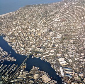
 Aerial view of Ballard and Lake Washington Ship Canal from the south | |
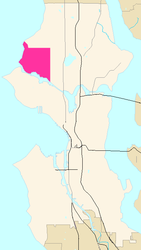
 Map of Ballard's location in Seattle | |
| Coordinates: 47°40′37″N 122°23′06″W / 47.677°N 122.385°W | |
| Country | United States |
| State | Washington |
| City | Seattle |
| Time zone | UTC-8 (Pacific Time) |
| • Summer (DST) | UTC-7 (Pacific Daylight Time) |
Ballard is a neighborhood in northwestern Seattle, Washington, United States. Formerly an independent city, the City of Seattle's official boundaries define it as bounded to the north by Crown Hill (N.W. 85th Street), to the east by Greenwood, Phinney Ridge and Fremont (along 3rd Avenue N.W.), to the south by the Lake Washington Ship Canal, and to the west by Puget Sound's Shilshole Bay.[1] Other neighborhood or district boundaries existed in the past; these are recognized by various Seattle City Departments, commercial or social organizations, and other Federal, State, and local government agencies.[2]
Landmarks of Ballard include the Ballard Locks, the National Nordic Museum, the Shilshole Bay Marina, and Golden Gardens Park. The neighborhood's main thoroughfares running north–south are Seaview, 32nd, 24th, Leary, 15th, and 8th Avenues N.W. East–west traffic is carried by N.W. Leary Way and N.W. 85th, 80th, 65th, and Market Streets. The Ballard Bridge carries 15th Avenue over Salmon Bay to the Interbay neighborhood, and the Salmon Bay Bridge carries the BNSF Railway tracks across the bay, west of the Ballard Locks.[1]
Ballard is located entirely within Seattle City Council District 6, which also includes the neighborhoods of Crown Hill, Green Lake and Phinney Ridge, as well as most of Fremont, North Beach/Blue Ridge, and Wallingford.[3] Ballard is part of the Seattle Public Schools and the Washington State Legislature's 36th legislative district. At the federal level, Ballard is part of the United States House of Representatives's 7th congressional district.
- ^ a b Seattle City Clerk, "Ballard neighborhoods", Geographic Indexing Atlas, The City of Seattle
- ^ Seattle City Clerk, "About the Atlas", Geographic Indexing Atlas, The City of Seattle
- ^ Seattle Department of Neighborhoods, Neighborhoods & Council Districts, The City of Seattle